- 1 Conditions
- 1.1 Entire Area
- 1.2 Monterey Bay
- 1.3 Carmel Area
- 2 Webcams
- 3 Old Sites
Are conditions good, or bad? These are the websites I use when I'm planning a dive trip.
Coming soon: How to read each site and compare the sites for each area. Always check the dates on the sites; broken sites may have old data!
Let me know if you have a favorite site that's not listed here!
Conditions
Entire Area
- Chuck Tribolet's Monterey Bay Sea Conditions (his discussion of how to read them is also useful)
- Coastal Data Information Program
- Facebook - Monterey County Dive Reports
- DiveCalif (a consolidation of several other forecast sites in frames)
- Monterey Health Department (water quality and beach advisories)
- National Weather Service (high surf and beach advisories)
- NOAA Near-Shore Wave Prediction System charts (wave height, wind speed, swell, current)
- Stormsurf (swells/waves)
- Surfer.com (wave forecast)
- TempBreak (look at Latest Chloro 3 Day Composite for algae levels)
- Tide tables: NOAA, Tideschart, WillyWeather
- Wavey (swells based on NWPS, with point data for San Carlos Beach and Breakwater)
- Weather Underground (10-day forecast)
Monterey Bay
(Monterey State Beach, San Carlos Beach, McAbee Beach, Lovers Point, Coral Street)
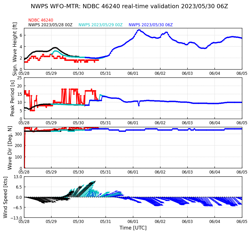
- NOAA buoy 46240 (off Lovers Point) has swell size and direction.
- NOAA buoy 46098 (middle of Monterey Bay) and NOAA station MEYC1 (on municipal wharf) have water temp and wind
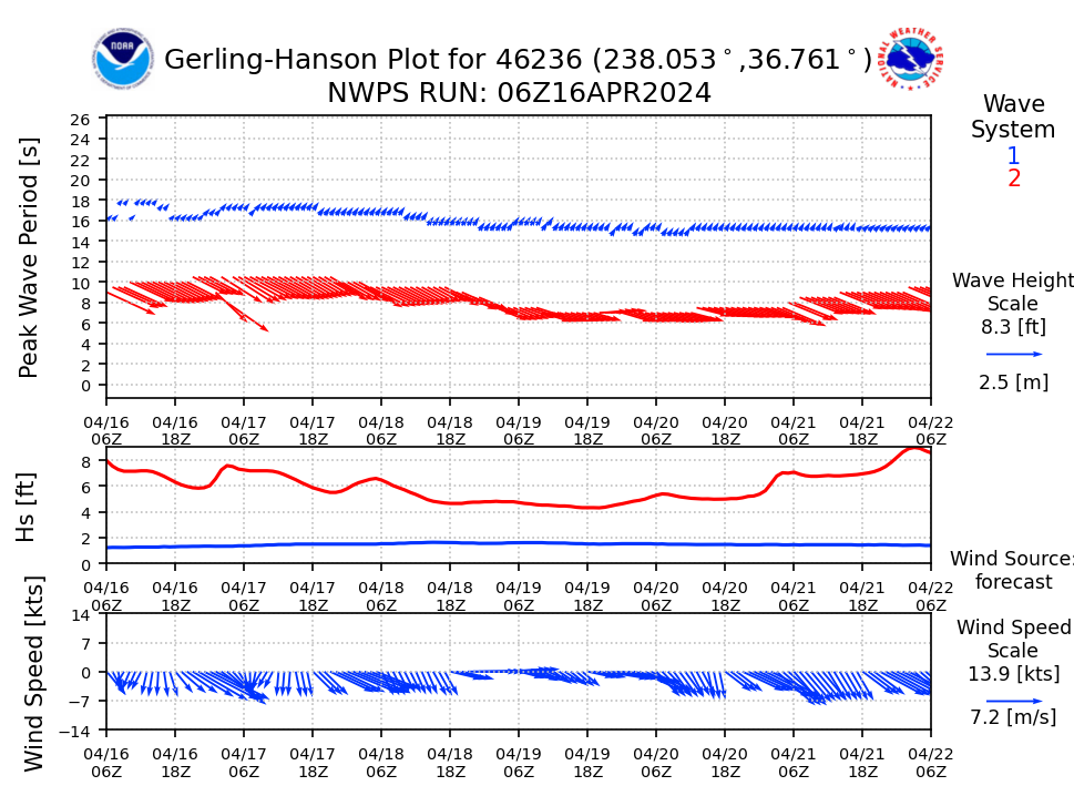
- NOAA buoy 46236 (middle of Monterey Bay; usually reads 2-3' higher than 46240) Near-Shore Wave Prediction System Hanson plot (times are UTC*)
- NOAA Weather Forecast (check for small craft advisory)
- Surf Forecast for Lovers Point
- WillyWeather (swell forecasts for San Carlos Beach and south, Lovers Point and north)
- Windy (swells; the waves and winds tabs are also useful)
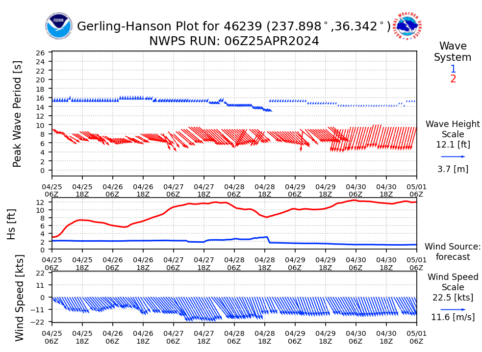
*NOAA predictions use UTC; subtract 8 hours (or 7 hours if daylight saving time) to get local time. This has the effect of shifting the data left (or the time axis right). For example, if NWPS shows a peak swell in Monterey bay at 11 pm Saturday, it's actually at 3 pm or 4 pm Saturday. That makes sense, because wind waves are highest in the afternoon. You can also look at the historical wave data from the corresponding buoy, which has both GMT/UTC and local time.
Carmel Area
(Stillwater Cove, Carmel River State Beach, Monastery Beach, Point Lobos)
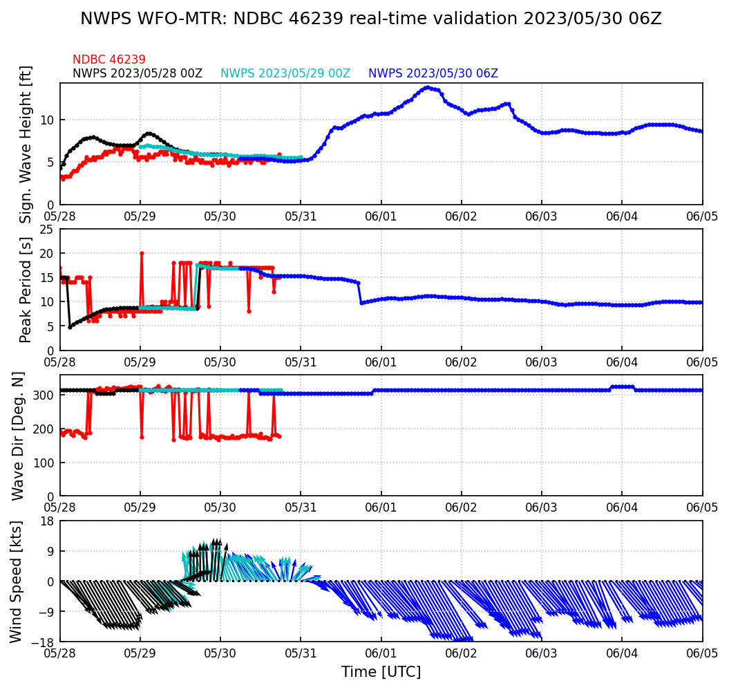
- NOAA buoy 46239 (off Big Sur)
- NOAA buoy 46239 Near-Shore Wave Prediction System Hanson plot (times are UTC*)
- NOAA Weather Forecast (check for small craft advisory)
- Surf Forecast for Carmel Beach
- Surfline report for Carmel Beach (happy surfers = sad divers)
- WillyWeather (swell forecast)
- Windy (swells)
Webcams
- Adventures By The Sea (pans from Hidden Beach and San Carlos Beach, over to the harbor with Monterey State Beach in the background)
- If the boat masts are rocking wildly in the harbor, it means there will be surge (even if it's calm at the surface).
- If there's sea foam at the point on the breakwater side, vis is likely to be less than 3'.
- If you can see whitecaps in the distance, there will be surge and lower vis in the shallows along the wall.
- Fish Hopper (McAbee Beach)
- Monterey Bay Aquarium (Cannery Row; has a 12-hour history.)
- Monterey Bay Kayaks (Monterey State Beach, but only shows yesterday's video)
- Pebble Beach (Stillwater Cove)
- Point Lobos (Whaler's Cove; Carmel River State Beach is also visible in the background)
- Portola Hotel Webcam (Monterey Harbor)
- Sanctuary Beach Resort (Marina, which is at the back of Monterey Bay. Shows how much wave energy is making it into the bay.)
- Tickle Pink Inn (Carmel)
Old Sites
Sometimes it's helpful to know what sites don't work anymore.
These are down as of 1/06/2026, but may return:
- A Taste of Monterey (Cannery Row; when it pans all the way to the right it shows offshore of McAbee)
- Carmel ClamCam (Carmel)
- NOAA buoy 46239 NWPS plot, alternate (times are UTC*)
- NOAA buoy 46239 WaveWatch bulletin (text format, times are UTC*)
- NOAA buoy 46240 NWPS plot, alternate (times are UTC*)
- NOAA buoy 46240 WaveWatch bulletin (text format, times are UTC*)
- SOFAR spotter buoy off McAbee Beach
- Solspot (5-day surf forecast)
- SwellInfo (kinda flaky/unreliable; may be missing data)
These are gone:
- SOFAR spotter buoy off Point Joe, (aka Bobby McBuoyFace). This broke loose in big swells in January 2023, traveling as far north as Mendocino before heading back south and disappearing 120 miles off the Monterey coast a month later.
These are just too hard to use at present:
- NOAA GFS FTP server is where the raw bulletins come out. But there isn't a 'latest' symlink, so you have to wander down the subdirectories to find a good run and go to the wave/station/bulls.t18z/gfswave.46240.bull file under that by hand.
- Surf Reports seems to miss big swells.